BVFF’s Redd Count and Mapping project wrapped up at the end of December. The club did 7 day-floats from Willow Lane (in mid-Garden City) down to Star to count and mark redds. Thanks to Johnny Rogers, George Butts, Jeff Jones and Klaus Kissman for their help. We delivered a few updates to the Flood District’s Redd-Map as well as discussed the possibility of repurposing a few downed trees into side channels for trout habitat. We are grateful to have such great partners who care about protecting and improving trout habitat in the Boise River.
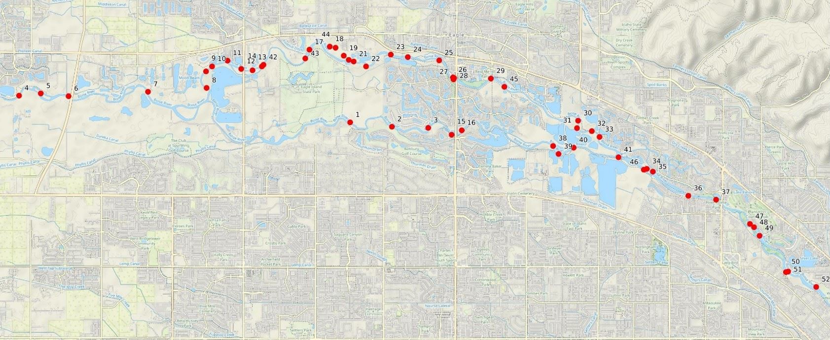
Figure-1 shows a high level map of the larger redd-zones we are tracking on the Boise River. For more details about BVFF’s “Redd Protection Program” with the Flood District, see this conservation blog article.
One thing I was looking for this year was how much new gravel the high spring flows stirred up. From what we observed, new gravel recruited from last spring’s high water was primarily deposited at “high water locations”, which are out of the water during the low flows of winter and unavailable for brown trout to spawn in November and December, but, this gravel will be available for rainbow trout to spawn when the flows come back up in the spring. We did see some changes to the river from high water which impacted brown trout spawning, including:
- Behind Lake Harbor a new gravel bar popped up in the middle of the river and the brown trout found it!
- A large spawning area behind Expo Idaho experienced shifts in a gravel-flat which impacted water depth and velocity—reducing the number of redds there this year;
- A 200-foot-long gravel island above Glenwood Bridge that used to have brown trout redds washed away and didn’t have any redds this year, but…there was new gravel accumulation nearby that did;
- Below Glenwood Bridge a run-riffle-run that had redds in the tail-out between them is now a single long run with no redds.
- The entry to New Dry Creek diversion was dewatered for a repair, which made a redd-zone unavailable this year. But the good news is once the project is complete there will be some “leftover gravel” there that brown trout will be able to use next year.
- In the side channel where BVFF did our gravel augmentation last year, most of our gravel was moved to the lower half of the side channel and left at higher water locations that are out of the water now but will be available to rainbow trout in the spring. The number of brown trout redds in the side channel was down this year as gravel in one redd-zone was washed away.
 Although there were changes to the river from high-water, the majority of the larger redd zones were active this year with an increase in the number of smaller spawning sites that just had 1 or 2 redds (which are not on this map). Overall we saw slightly fewer redds this year but we know that there was some late spawning this year and and it is possible that we missed some redds that were in new locations. And, as described above, there were some changes to several of the larger redd-zones in the main channel this year that resulted in fewer redds at those sites. I also feel like we are getting more accurate at our redd counts and avoiding some areas of current-scour that we may have mistakenly counted as a redd in previous years.
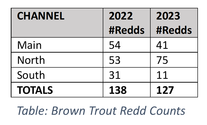
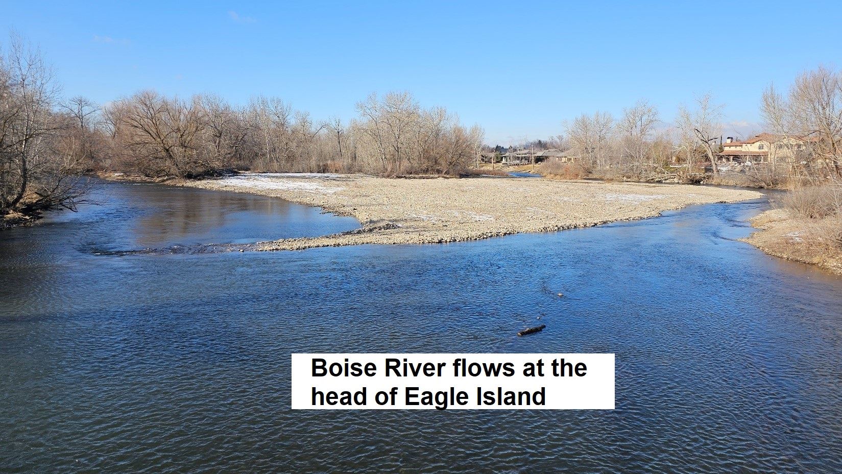
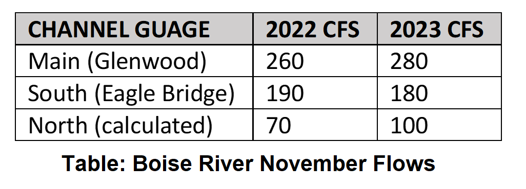 Below Glenwood bridge the Boise river splits into 2 channels that flow around Eagle Island, as shown in the photo below. The north channel has many more small twists and turns than the south channel, which causes the river to drop more gravel and improves trout spawning habitat there, resulting in more spawning activity (which you can see by how many redd-zones the north channel has on the map). The amount of water entering the north channel varies from year-to-year depending on cobble accumulations at the head of Eagle Island. Table-2 shows the flows in November of 2022 vs 2023 and you can see how the north channel got more water this year, which made more spawning habitat available to the brown trout and is likely the reason we saw more spawning activity in the north channel this year. Brown trout are known to migrate to find spawning habitat and based on the redd counts the last 2 years it looks like some of them may have decided to spawn in the north channel this year because of the favorable conditions.
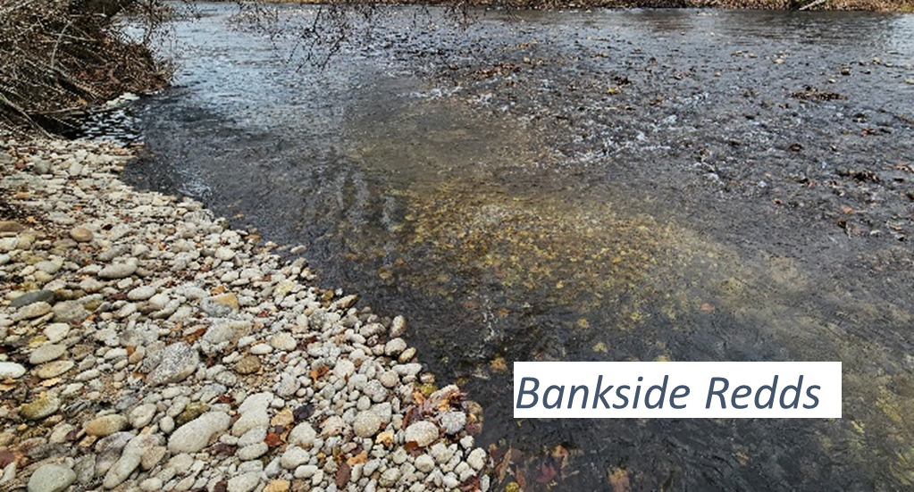
Many of the brown trout redds on the Boise River are close to the bank where the river has recruited gravel, like the redds shown in the photo below. Because of this, water flows are a big factor in what bankside spawning habitat is available to brown trout in the winter. Low winter flows dewater some side channels and as water levels go down the river recedes from the banks where much of the spawning gravels are located.
In the 1980s and 90s, Idaho Fish and Game worked to establish minimum winter flows in the Boise River which significantly improved the wild trout populations because it brought water levels up and improved access to trout spawning and rearing habitat. When we have good reservoir carryover conditions (like this winter) the Boise river typically runs around 270cfs - 280cfs at the Glenwood Bridge gauge during the winter but in drought years that drops to around 210cfs or even lower, which dewaters the banks more. IDFG has some water rights in Lucky Peak and has been investigating increasing the minimum winter flows to 300cfs to improve trout spawning and over-wintering habitat which would be a great improvement for the wild trout on the Boise river and I would love to see it happen—even if it only happened on years when we have a good reservoir carryover.

